What Air Mass Wins During A Stationary Front
Kalali
Mar 15, 2025 · 7 min read
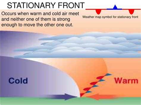
Table of Contents
What Air Mass Wins During a Stationary Front? A Deep Dive into Weather Patterns
Stationary fronts, those frustrating periods of prolonged unsettled weather, represent a stalemate between two contrasting air masses. Unlike a cold front's swift advance or a warm front's gradual creep, a stationary front sees a tug-of-war, with neither air mass dominating. But the question remains: does one air mass ultimately "win"? The answer is nuanced and depends on several factors. Let's delve into the complexities of stationary fronts and unravel the dynamics at play.
Understanding Stationary Fronts: A Battle of the Air Masses
A stationary front forms when a boundary between two air masses becomes nearly stagnant. This happens when the opposing forces of the two air masses are relatively equal, resulting in little to no movement of the front. The front may oscillate slightly, but its overall position remains relatively unchanged for an extended period, often several days. This prolonged period of stalled weather systems often leads to persistent cloud cover, precipitation, and generally unsettled conditions.
Identifying the Contenders: Warm and Cold Air Masses
The core of a stationary front is the boundary separating two distinct air masses:
- Warm Air Mass: Characterized by higher temperatures and greater moisture content. This air mass is typically less dense and rides above the colder air.
- Cold Air Mass: Characterized by lower temperatures and drier conditions. This air mass is denser and tries to wedge underneath the warmer air.
The battle between these two air masses is what defines the stationary front. The outcome, in terms of which air mass ultimately prevails, isn't a simple victory but a complex interplay of atmospheric forces.
Factors Determining the "Winner" (or the Lack Thereof)
Several atmospheric factors influence the eventual evolution of a stationary front:
1. The Strength of the Air Masses: A Clash of Titans
The strength of each air mass plays a significant role. A particularly strong cold air mass might eventually overcome the warmer air, leading to a cold front breakthrough. Conversely, a robust warm air mass could push back the cold air, resulting in a warm front advancement. The relative strength is determined by factors such as the temperature difference between the air masses, the pressure gradient, and the wind speeds. A more significant temperature gradient generally indicates a stronger driving force for the front's movement.
2. Upper-Level Winds: The Invisible Hand Guiding the Battle
Upper-level winds, or winds in the atmosphere above the surface, significantly influence the movement of the front. These winds can either reinforce the existing stalemate or provide a push to one air mass, causing the front to break down and transform into either a cold front or a warm front. If the upper-level winds are parallel to the front and flow in the same direction as the warmer air mass, it can strengthen the warm air mass and prevent the cold air from advancing. Conversely, upper-level winds opposite to the warm air mass movement could allow the colder mass to advance.
3. Jet Stream Influence: A Powerful Current Shaping the Conflict
The jet stream, a high-altitude, fast-flowing air current, plays a crucial role in influencing the behavior of stationary fronts. The jet stream's position and strength directly affect upper-level winds and the overall atmospheric pressure patterns. A strong jet stream could accelerate the movement of one air mass, while a weaker jet stream might prolong the stalemate. The position of the jet stream relative to the stationary front can dictate the direction and speed of any eventual shift. A jet stream positioned favorably for a cold air mass advance could lead to the cold air mass winning, effectively transforming the front.
4. Surface Friction: Slowing Down the Contestants
Surface friction, the resistance encountered by air masses as they move across the Earth's surface, slows the movement of both air masses. This effect is particularly pronounced over rough terrain, such as mountainous regions or forested areas, which can act to hinder the progress of either the warm or cold air mass. This added resistance contributes to the prolonged stagnation characteristic of a stationary front. The impact of surface friction is more pronounced on the colder, denser air mass, potentially slowing its advance compared to the warmer, less dense air.
5. Differential Heating: The Sun's Role in the Dispute
Differential heating, the uneven warming of the Earth's surface, can influence the strength and movement of air masses. Land areas warm and cool more rapidly than water bodies. This can lead to variations in air pressure and temperature gradients, affecting the stability of the front. For instance, daytime heating could strengthen the warmer air, while nighttime cooling could give the colder air an advantage.
The Transformation: When a Stationary Front Breaks
A stationary front doesn't persist indefinitely. Eventually, one air mass will gain the upper hand, leading to the front's transformation:
- Transition to a Cold Front: If the colder air mass eventually overcomes the warmer air, the stationary front transforms into a cold front. The cold air mass will then actively push the warm air upward, leading to a period of intense precipitation and often followed by colder and clearer conditions.
- Transition to a Warm Front: Conversely, if the warmer air mass gains dominance, the stationary front transforms into a warm front. The warmer air will slowly rise over the colder air, generating widespread, often lighter precipitation and warmer temperatures.
The transformation isn't a sudden switch but a gradual process dictated by the interplay of atmospheric factors already discussed. The rate of transformation varies widely depending on the strength of the air masses and the influence of other factors.
Predicting the Outcome: A Weather Forecaster's Challenge
Predicting which air mass will "win" in a stationary front scenario is challenging, even for experienced meteorologists. It requires analyzing various factors, including:
- Satellite Imagery: Provides a broad overview of cloud patterns and the overall structure of the front.
- Surface Weather Charts: Show the temperature and pressure gradients, providing insights into the strength of the air masses.
- Upper-Air Charts: Reveal upper-level winds and the position of the jet stream, crucial factors in the front's movement.
- Numerical Weather Prediction (NWP) Models: Sophisticated computer models incorporate various data inputs to simulate atmospheric dynamics and predict the future evolution of the front.
Even with advanced tools and techniques, forecasting the evolution of a stationary front remains an area of active research. Small changes in initial conditions can lead to vastly different outcomes, underscoring the complexity of the system.
The Impact of Stationary Fronts: More Than Just Rain
Stationary fronts significantly impact weather patterns, leading to:
- Prolonged Precipitation: Days or even weeks of persistent rain or snow, depending on the temperature and moisture content of the air masses.
- Cloud Cover: Persistent overcast conditions can limit sunshine and reduce temperatures.
- Fog: The combination of moisture and low temperatures can lead to the formation of fog.
- Strong Winds: As the air masses push against each other, strong winds can develop.
The impact can vary depending on the geographical location and the specific characteristics of the interacting air masses. Coastal areas, for example, might experience intensified precipitation due to moisture sourced from the nearby water body.
Conclusion: A Complex Atmospheric Stalemate
Determining which air mass "wins" in a stationary front scenario is not a matter of simple dominance. It's a complex interplay of multiple atmospheric factors that ultimately determine whether the front transitions into a warm or cold front or persists in its stationary state for an extended duration. Understanding these factors is crucial not only for accurate weather forecasting but also for mitigating the impact of potentially prolonged periods of unsettled weather. Continued research and advanced modeling techniques are continuously refining our understanding of these complex atmospheric phenomena.
Latest Posts
Latest Posts
-
What Is 2 And 1 4 As A Decimal
Mar 15, 2025
-
Is A Fox A Secondary Consumer
Mar 15, 2025
-
The Answer In A Division Problem Is The
Mar 15, 2025
-
What Is 24 40 As A Percentage
Mar 15, 2025
-
What Are The Two Parts Of Solution
Mar 15, 2025
Related Post
Thank you for visiting our website which covers about What Air Mass Wins During A Stationary Front . We hope the information provided has been useful to you. Feel free to contact us if you have any questions or need further assistance. See you next time and don't miss to bookmark.
