What Is Depression On A Topographic Map
Kalali
Apr 01, 2025 · 6 min read
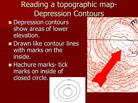
Table of Contents
What is Depression on a Topographic Map? A Comprehensive Guide
Topographic maps are powerful tools used to represent the three-dimensional surface of the Earth on a two-dimensional plane. They utilize contour lines to depict elevation changes, revealing hills, mountains, valleys, and other landforms. One such feature, often causing confusion for beginners, is a depression. This article will delve deep into understanding what a depression is on a topographic map, how it's represented, and its significance in various contexts.
Understanding Contour Lines: The Foundation of Topographic Maps
Before we explore depressions, let's solidify our understanding of contour lines. These lines connect points of equal elevation. Imagine walking along a contour line; you'd neither ascend nor descend. The closer the contour lines are to each other, the steeper the slope. Conversely, widely spaced contour lines indicate a gentler slope. This density variation is key to interpreting the terrain depicted.
Key Characteristics of Contour Lines:
- Equal Elevation: All points along a single contour line share the same elevation.
- Never Cross: Contour lines never intersect or cross each other. An intersection would imply a single point having two different elevations, which is physically impossible.
- Close Spacing = Steep Slope: Closely spaced contour lines indicate a steep slope, while widely spaced lines show a gentle slope.
- Closed Loops: Contour lines often form closed loops, representing hills or mountains (closed loops with higher elevations inside) or depressions (closed loops with lower elevations inside).
- Index Contours: Thicker lines, usually labeled with their elevation, are called index contours. They help in quickly determining elevation values.
- Supplementary Contours: These are thinner lines, added between index contours to enhance detail and precision.
Identifying Depressions on Topographic Maps: The Hachured Contour Lines
Depressions on topographic maps are represented by closed contour lines with short, perpendicular lines called hachures. These hachures point inwards towards the center of the depression. This distinguishes a depression from a hill, which features closed contour lines without hachures. The hachures indicate that the enclosed area is lower than the surrounding terrain. They don't just mark a dip; they signify a relatively enclosed, lower-lying area.
Understanding Hachures: The Key to Depression Identification
The presence of hachures is crucial for identifying depressions. Without them, a closed contour line could simply represent a hilltop. Hachures unequivocally indicate a low point in the landscape. The density of the hachures can sometimes suggest the steepness of the depression's sides, although this is not always consistently applied across all maps.
Types of Depressions and their Representations:
While the hachured contour line method is the standard for representing depressions, the complexity and size of the depression can lead to variations in their representation:
1. Closed Depressions:
These are the most straightforward types, represented by entirely closed contour lines with hachures pointing inwards. They are relatively contained and often represent features like sinkholes, craters, or small basins. The depth of the depression can be determined by comparing the elevation of the innermost contour line with the surrounding higher elevation contour lines.
2. Open Depressions:
Unlike closed depressions, these connect to a drainage system. They are often represented by contour lines with hachures that are not entirely closed loops. They might have one or more open ends where they connect to a valley or stream. These depressions might represent a low-lying area along a river or a gully.
3. Complex Depressions:
Some depressions might be complex, involving a nested system of smaller depressions within a larger one, or depressions with irregular shapes. In such cases, the hachuring becomes more critical for understanding the overall topography. The pattern of hachures will guide the interpretation of the nested or interwoven depressions.
Importance of Depressions in Various Fields:
Understanding depressions on topographic maps is critical across various disciplines:
1. Hydrology and Water Management:
Depressions often play significant roles in hydrological processes. They can act as natural reservoirs, collecting rainwater and influencing drainage patterns. Analyzing depressions helps in designing drainage systems, managing water resources, and predicting flood risks. Identifying the size, shape, and depth of depressions is essential for effective water resource planning.
2. Geology and Geomorphology:
Depressions are significant landforms shaped by geological processes such as erosion, subsidence, or impact events. Their characteristics can provide valuable insights into the geological history of an area. Identifying the type and origin of depressions can contribute to understanding the geological evolution of a region.
3. Civil Engineering and Construction:
Understanding depressions is critical for planning and constructing infrastructure. Depressions need careful consideration when designing roads, buildings, and other structures. Construction within or near depressions may require specialized engineering solutions to handle potential flooding or stability issues.
4. Environmental Studies and Conservation:
Depressions often support unique ecosystems, providing habitats for specific plants and animals. Understanding the distribution and characteristics of depressions is crucial for conservation efforts and environmental management. Protecting these areas contributes to biodiversity conservation.
5. Military Applications:
Depressions can serve as potential defensive positions or hiding places, depending on their size and concealment. Military strategists utilize topographic maps to identify and analyze such features to gain tactical advantages. The ability to understand the terrain using contour lines is extremely important for military planning.
Practical Applications and Interpretation Exercises:
To solidify your understanding, let's consider some hypothetical scenarios:
Scenario 1: A closed contour line with several concentric rings and hachures pointing inwards. This indicates a relatively deep and well-defined depression, possibly a sinkhole or crater.
Scenario 2: An elongated depression with hachures only on one side of a contour line, open on the other end. This likely represents a gully or ravine connected to a drainage system.
Scenario 3: A series of nested contour lines with hachures, forming a complex depression. This might signify a karst landscape with multiple sinkholes interconnected.
By analyzing the contour lines, their spacing, and the presence and direction of hachures, you can accurately interpret the type, size, and characteristics of the depression.
Advanced Techniques and Considerations:
While basic interpretation involves identifying hachures within closed contour lines, advanced analysis can incorporate other factors:
- Slope Analysis: The spacing of contour lines near the depression provides information about the steepness of its sides.
- Drainage Patterns: Observing how water flows into and out of the depression reveals crucial hydrological information.
- Cross-Sections: Constructing cross-sections from contour lines provides a clearer three-dimensional view of the depression's profile.
- Digital Elevation Models (DEMs): Modern techniques often use DEMs to create three-dimensional representations of the terrain, which allow for a more detailed analysis of depressions.
Conclusion: Mastering the Depths of Topographic Maps
Understanding depressions on topographic maps is an essential skill for anyone working with geographical data. By mastering the interpretation of hachures and contour lines, you unlock the ability to analyze complex terrain, understand hydrological processes, and make informed decisions across a variety of fields. This comprehensive guide has equipped you with the knowledge and techniques necessary to confidently navigate the depths of topographic maps and extract valuable insights from the data they represent. Through practice and application, your understanding of these crucial landforms will continue to grow. Remember that the consistent and careful analysis of topographic maps is paramount for extracting meaningful information about depressions and other critical features represented on the map.
Latest Posts
Latest Posts
-
Cuanto Es 20 Libras En Kilos
Apr 02, 2025
-
The Shaft Of A Long Bone Is The
Apr 02, 2025
-
What Four Substances Are Recycled During Photosynthesis And Respiration
Apr 02, 2025
-
What Is 4 Inches In Millimeters
Apr 02, 2025
-
How Many Fluid Ounces Is A Liter
Apr 02, 2025
Related Post
Thank you for visiting our website which covers about What Is Depression On A Topographic Map . We hope the information provided has been useful to you. Feel free to contact us if you have any questions or need further assistance. See you next time and don't miss to bookmark.
